©1993 by James P. Riser
My "An Introduction to Image Processing" CD was created so that others might share in the
excitement of using digital image processing techniques as science research tools. Students in
my middle school science classes and those in science classes of over 200 hundred other
teachers around the country have been "turned on to science" by these innovative activities. It
is my hope that many others will now share in this excitement with the availability of the
necessary software, digital images, and interactive tutorials.
The image processing activities range from interesting introductory lessons to analysis of
environmental satellite images. The topics covered include:
Empty Head (MRI scan), Night Lights (coordinates and satellite images), Trea$ury Agent
(saving the U.S. Tresaury by undoing the damage done by correcting counterfeit $100 bills),
License Plates (enhancing images to trap a drug dealer), Comparative Skeletal Anatomy
(comparison of many skeletal systems for similarities/differences),
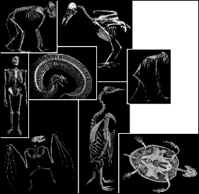
Human Skeleton Activity (creating a color coded human skeleton), A Trip to the Boneyard
(a fun skeletal assembly activity), Animating Saturn's Rings (cleaning up NASA raw images
and assembling them into an animation sequence),

Volcanic Plumes on Io (enhancing raw images of Io to reveal volcanic plumes),

Tree Ring Dating (exploring the art of tree ring dating),

Creating an Indexed Color Image (creating a color image from three grayscale components),
Solar Eclipse of 1991 (calculating speed of shadow's movement from satellite images),

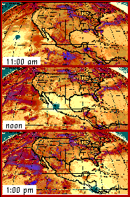
Hurricane Movement Studies (analysis of many satellite images and weather maps to
determine forces acting upon the movement of a hurricane),

Skull and Facial Symmetry (exploration into the concept of symmetry),

Indirect Solar Flare Measurement (utilizing image processing techniques to determine the
speed and size of a solar flare),

Satellite Simulation Activity (simulation of satellite reception involving the participation of
several local schools), The Water Cycle (introduction to the water cycle), Computerized
Contour Maps (creating computerized contour maps from images of a small contour model -
an evaluation of remote sensing techniques),

Using Topographic Maps (practice in matching topo maps to aerial photos of the same
area), Remote Sensing Meteor Crater (analysis of remote sensing measuring techniques),
Creating a 3-D Contour Map (making a three dimensional map from a topo map),

Land Use Analysis (analyzing aerial photos to calculate percentages of land uses), Object
Identification (exploration using the computer to identify objects), Seasonal Ice Changes
(exploration into seasonal ice changes at both poles),
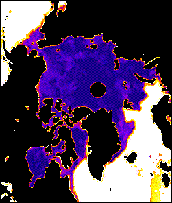

Northern Seaports and Ice (students create a shipping route to avoid seasonal ice
problems), Global Warming (analysis of Northern Ice Cap, Southern Ice Cap, Ocean
Temperatures,


and Phytoplankton Pigment Concentration images over a period of time),

and Measuring the Ozone Layer (measuring the thickness of the ozone layer for any number
of locations on the earth over a period of time).
In addition to the above listed activities and documentation, there are many extra QuickTime
movies and color images for exploration. As a bonus this CD includes a special public
domain software and/or shareware section. This carefully selected assortment of software
should be very useful to those using the activities on this CD. Final note: The CD-ROM was
written and produced before the Power Macs came on the market. Therefore some of the
shareware software is now out of date. The contents have been presented here so that you
might better understand some of my work. The activities are as good as ever, though!